Same Streets
Photographs

Report a rights issue

If this photograph is yours, tell us. We review every claim that comes with evidence, and we would rather lose a picture than keep one that someone else holds the rights to.

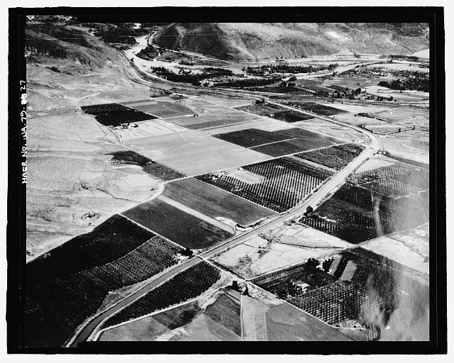
27. Photographic copy of photograph, Joseph Yolo, photographer, 1936 (original print located at U.S. Bureau of Reclamation Upper Columbia Area Office, Yakima, Washington). "WAHT A GOVERNMENT CANAL AND AN ASSURED WATER SUPPLY WILL DO IN A DESERT AREA IS SHOWN IN THIS AIR VIEW OF A SECTION OF THE YAKIMA FEDERAL RECLAMATION PROJECT IN CENTRAL WASHINGTON. THE MAIN CANAL IS SEEN RUNNING DOWN THE MIDDLE OF THE VALLEY WITH PATCHES OF ORCHARDS AND FIELDS ON EITHER SIDE, BUT ABOVE THE CANAL LINE THE SAGE BRUSH DESERT REMAINS, AS CAN BE SEEN ON THE LEFT. THE YAKIMA PROJECT SUPPORTS MORE THAN 110,000 PEOPLE IN A TERRITORY WHICH WAS DESERT 35 YEARS AGO. MANY OF THE ORIGINAL SETTLERS WHO CAME, LIKE THOSE WHO ARE NOW SETTLING ON THE VALE PROJECT, TO BREAK THE RAW DESERT LAND, ARE STILL LIVING ON THESE NEATLY CHECKERBOARDED FARMS" - Kachess Dam, Kachess River, 1.5 miles north of Interstate 90, Easton, Kittitas County, WA
27. Photographic copy of photograph, Joseph Yolo, photographer, 1936 (original print located at U.S. Bureau of Reclamation Upper Columbia Area Office, Yakima, Washington). "WAHT A GOVERNMENT CANAL AND AN ASSURED WATER SUPPLY WILL DO IN A DESERT AREA IS SHOWN IN THIS AIR VIEW OF A SECTION OF THE YAKIMA FEDERAL RECLAMATION PROJECT IN CENTRAL WASHINGTON. THE MAIN CANAL IS SEEN RUNNING DOWN THE MIDDLE OF THE VALLEY WITH PATCHES OF ORCHARDS AND FIELDS ON EITHER SIDE, BUT ABOVE THE CANAL LINE THE SAGE BRUSH DESERT REMAINS, AS CAN BE SEEN ON THE LEFT. THE YAKIMA PROJECT SUPPORTS MORE THAN 110,000 PEOPLE IN A TERRITORY WHICH WAS DESERT 35 YEARS AGO. MANY OF THE ORIGINAL SETTLERS WHO CAME, LIKE THOSE WHO ARE NOW SETTLING ON THE VALE PROJECT, TO BREAK THE RAW DESERT LAND, ARE STILL LIVING ON THESE NEATLY CHECKERBOARDED FARMS" - Kachess Dam, Kachess River, 1.5 miles north of Interstate 90, Easton, Kittitas County, WASnoqualmie Pass, Kittitas, WACredit: Library of Congress (HABS/HAER)Rights: public domain · photograph #22169

Evidence is required. A claim without a link to evidence that you hold the rights is not reviewed. That is what stops anyone from removing a photograph with a bare assertion.
So we can answer you. Only the archive's editors see it.

Required. A web page that shows you hold the rights.

What the link shows
What you would like us to do

How the photograph is yours: who took it, when, and where it first appeared.

What happens next

  1. A person reads your claim and opens your evidence. The photograph is not touched until then.
  2. If the claim is verified, we do what you asked. A removal takes the photograph down from the site and the map — it is kept in our records with your claim, not deleted. A credit correction changes the credit, and the photograph stays up.
  3. We answer you at the contact above, either way, and say why.
  4. The decision goes on the public log: its date, the kind of evidence and the outcome. Never your name or contact details.